|
|
|
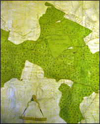
Part of Whittlewood Forest c.1608
|
The designation of Forest Law areas was mostly a Norman imposition to protect the King’s hunting and to raise revenue for the King through the levying of fines. The King’s Forest officials fined severely for offences such as killing deer, clearing woodland, or keeping hounds in the forest. Northamptonshire had three huge areas in which forest law applied from the earliest Norman times. By the middle of the 12th century over half Northamptonshire was under forest law at the King’s command, including Whittlewood Forest, which encompassed lands in Cosgrove and Furtho. This land included open spaces, deer parks, enclosures and assarts, as well as woodland with trees, villages and open fields within parishes.
Cosgrove and Furtho were closely linked at times in this period – although each had a church the parishes were intermixed as can be seen from furlong names. Kenson Field, probably also woodland, belonged to Cosgrove, part of a larger area called Brownswood. The following map shows the Whittlewood landscape in around 1200 – Cosgrove and Furtho may have had rights of common in the forest area, and names like “close”, “stocking” and Green” are probably indicators that places were once woods.
The bounds of the Forest of Whittlewood in the perambulation of 1299 noted areas of private woodland, and grants of liberties and franchises such as free warren (meaning that the landowner could take certain game without restriction) were made to landowners within the area technically forest. This included specifically “the woods of Cosgrove and of Forho of the prior of Snelshall”.
Snelshall Priory was a Benedictine priory in Milton Keynes, the United Kingdom, built around 1200. The priory was started after Sybil d'Aungerville granted land at Tattenhoe to Lavendon Abbey, who most likely started a cell at Snelshall. The priory accumulated various land through gifts, but even with all these grants, in 1321 when Henry Burghersh visited, it was so poor that "the monks scarcely had the necessities of life and had to beg even for these".
The Cosgrove woodlands may have included forest land in Puxley, which at various times was owned by Cosgrove people. From the earliest records of Whittlewood Forest, Puxley was the place where the chief forester was based, and from which forest law was controlled, granted as a residence around 1175. Areas called Scrob (1220) and Pokeslescrob (1221) Nottpokesle Wood (c1290) and Nottewode (1373) are recorded as woods in Crown woods, later called coppices, which appear time and again as being under the ownership of Cosgrove residents. In 1286 the perambulation boundary of the forest included Old Stratford.
We can probably assume, therefore, that during the 12th and 13th centuries Cosgrove would have been under forest law.
The matter of clearing woodland, or assarting, either to take timber or to convert the land to arable or pasture, was a serious one, as we can see from the 1202 Assize records where Hugh Revel was in dispute over woodland in Cosgrove. This was acknowledged to be his own land but with assarting rights allowed to tenants, which he had ignored, taking the wood for himself.
In 1249 woodland in Puxley and Shrob was destroyed by assarting – these areas were later called “closes”.
In the early 14th century a list of “perambulations” of the forest specified that the wood of Henry Spigurnel with the vill of Cosgrove, and the wood of Adam de Forho were no longer to be considered part of Whittlewood Forest and therefore no longer subject to forest law. Edward I and his son did their best to prevent this large scale disafforestation, but it considerably reduced the size of Whittlewood.
Forest law would have over-ridden all such local arrangements and it must have been a great relief when Cosgrove was declared outside its jurisdiction, even though some lands in Puxley and Shrob wood still lay inside the Whittlewood area. The judgement also increased the value of the manor of Cosgrove, as it freed its lord from liability to restrictions on his own land – leaving him free to exploit it himself.
Cosgrove’s landowners in 1301 at the time of the lifting of Forest Law in the vill are listed here.
The Extent of Whittlewood Forest and the Impact of Disafforestation in the Later Middle Ages” by Mark Page (2003)
The Forests of Northamptonshire in the Early Middle Ages by J M Steane (1973)
The Woodland Landscapes of Southern Northamptonshire by David Hall (2001)
|
|
162 – Assize Rolls
TIMBER STEALING RIOTS IN WHITTLEBURY AND SALCEY FORESTS, IN 1727-28 (104,107) –
XX. A List of the Persons names which were bound over to the Assizes for unlawfully cutting down and carrying away sevll trees out of the Forests of Salcey and Whittlewood belonging to his Mtie.
Causegrave ……. 3 persons
From "The History of Stony Stratford" F E Hyde and S F Markham, 1948
In 1769 the Shrob came right down to the Old Stratford – Deanshanger Road and formed a dense wood with many alleys in which strangers could easily get lost. The Shrob Walk was divided into five copses, the one nearest the Old Stratford crossroads being called Sallow Copse, and to its north were Eustilus and Bears Watering Copse, which extended to Puxley. Along the Deanshanger Road were first pond Riding Copse and then Cole Copse, which stretched to within sight of Deanshanger.
The original Shrob Lodge, which burned down in around 1850, was built in the 17th century for Thomas Willis of Whaddon, and it was here that his son Browne Willis, the great Buckinghamshire historian, spent much of his youth. It then passed to the Hartley family of Stony Stratford for a few years and for a century after that was inhabited by the keeper of Shrob Walk.
In 1791 there was a Survey by the Commissioners of Woods and Forests. Whittlewood was computed to be 32 square miles in extent – 5424 acres, of which 295 acres were in the Shrob, 514 in Hanger Walk, and 1814 in Wakefield Walk. The forest was still famous for its oaks, for in the previous two centuries it had provided over 51,000 for the Royal Navy and the Royal Palaces.The Shrob was the only part of the forest constantly enclosed with rails.
As a result of this survey, the resolution was taken to deforest the Shrob and to bring the whole area under cultivation. By 1820 all Puxley was clear, and North Field Farm had been created. Within another twenty years all had been cleared except a small spinney near the Shrob and a tiny triangle of trees north of North Farm. The last deer in Shrob Walk was killed in 1800. In the rest of Whittlewood deer were kept until the 20th century and Robins’ Diary records that in 1854 nearly 400 deer were caught or killed in a four day hunt. Robins was an observant old grazier who lived at the King’s Head.
|
|
1951 Northamptonshire Past and Present Vol 1 Issue 4 p22 The Gallows
In earlier times there was a grimmer punishment than transportation for sheep and deer stealing. My old friend, Mr Jack Brown of Cosgrove, once pointed out to me an oak tree standing back from the high road on the County boundary between Northamptonshire and Buckinghamshire, close to the lodge gate of Thornton Hall.
“This is Cranley Oak, “ he said, “where they used to hang the sheep and deer stealers, and they used to put a stake through ‘em and bury ‘em by the side of the road.”
A little documentary evidence in support of this tale would be acceptable. It is possible, however, that this tree may have been on or near the site of the private gallows of the Lord of the Manor in the Middle Ages. These traditions get handed down orally from generation to generation and scepticism may sometimes lead us as far astray as over credulity.
|