|
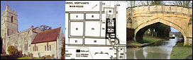
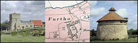
a(9) DESERTED MEDIEVAL VILLAGE OF FURTHO AND GARDEN REMAINS (SP 773431; Fig. 96), lie against the modern boundary between Potterspury and Cosgrove, on the S. side of a small valley, on Boulder Clay at 75 m. above OD. The medieval parish of Furtho included land to the N. and S. now in Cosgrove and Old Stratford (Fig. 16). The village is first mentioned in Domesday Book when it was divided into three small holdings with a total recorded population of 15 (VCH Northants., I (1902), 15). However, one of these manors may have been the deserted hamlet which lies to the S. in the part of Old Stratford formerly in Furtho parish (Old Stratford (9). Furtho is named in the Nomina Villarum of 1316. No indication of its later medieval population is available as it was always taxed with Cosgrove, except in 1525 when three people paid the Lay Subsidy (PRO, E179/155/130). in 1547 200 sheep were maintained on the manor. Around 1600 Edward Furtho, a member of the family who had held the manor since the 13 th century, enclosed the parish, de-populated the village, diverted the main through road and rebuilt the church. The existing building is said to be of about 1620 (N. Pevsner, Northamptonshire (1961), 212; K. J. Allison et al., The Deserted Villages of Northants. (1966), 40).
An Inventory of Archaeological Sites in South - West Northamptonshire
Historical Monuments Page 119
By 1720 'only one house, with the church', survived although 'the remains of a former village' were still to be seen (J. Bridges, Hist, of Northants., I (1791). 296). The house is shown standing to the S.W. of the church, together with the remains of its formal garden, on a map of 1835 (NRO; sec also Tithe Map, 1850). It was demolished in the late 19th century and replaced by the present Manor Farm to the S.
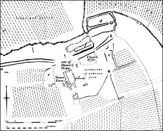
A circular stone dovecote, said to be of the 15th century, is shown immediately S. of the original house and still remains.
Apart from one of the medieval fishponds, now dry, and part of the post-medieval garden, no earthworks have survived the extensive modern agricultural improvements. However, from air photographs taken before destruction (RAF VAP CPE/UK/1926, 2245-6; CUAP, XT35), more recent air photographs (in NMR) and the modern OS 1:2500 plan (SP 7743) it is possible to reconstruct a plan of the earthworks as they existed in 1947 (Fig. 96). The main feature ol the site was a broad hollow-way ('a'-'b' on plan), presumably the main through road, which ran approximately E.-W. parallel with the stream. At its W. end its line is continued by a broad curving headland which once joined Furtho Lane in Potterspury village but the E. extension of the road cannot be traced. The part of this hollow-way immediately N.E. of the church was between 9 m. and 18 m. wide. Immediately to the S. of this, E. of the church ('c' on plan), there was a series of rectangular paddocks bounded by banks and ditches with, to the S. again, a large circular mound 20 m. in diam. and 1 m. high which still partly survives. To the N. of the hollow-way ('d' on plan) were two long rectangular fishponds separated by a low bank and bounded on the E. by a broad dam. Only the northern pond now survives with the dam up to 2 m. high. Along the valley side to the W. of the church and N.W. of Manor Farm there were other more indeterminate earthworks ('c').
The post-medieval garden (f on plan) lay immediately N. of the church and N.E. of the site of the old manor house. As its remains lie across the alignment of the medieval hollow-way, the garden must have been constructed after the road was put out of use. The 1835 map shows a long rectangular area divided into rectangular flower beds with what appears to be a shrubbery to the N. between the flower beds and a large pond. This pond, together with the scarp 1m. high which apparently marks the division between the flower beds and the shrubbery, survives though in poor condition.
|