|
277.
|
1900
|
|
|
Map 4497
Ordnance Survey Northants Sheet L X 1. 2
Scale: 25 ins to 1 mile showing Badger's Farm in Cosgrove, The Grand Junction Canal at Isworth Farm Castlethorpe Wharf with Castlethorpe Mill Arnold's Charity estate in Furtho shown in pink colour wash.
|
|
|
|
278.
|
|
|
|
Map 4498
Ordnance Survey Map Northants Sheet L X 1. 6
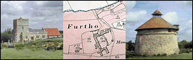
Scale: 25 ins to 1 mile showing the parish of Furtho & part of Cosgrove. Colour washed in pink to show Furtho Manor estate (surrounding the church)
In pencil: position of septic tank a new farmhouse.
|
|
|
| 279. |
1926
|
|
Map 4499
Ordnance Survey Map of Potterspury a Furtho (Northants Sheet L X 1 N,W.) 1926 Edition Scale: 6 ins to 1 mile
With the Arnold Furtho charity estate coloured in pink wash.
|
|
|
280.
|
|
|
Map 4500
Plan of drainage in a field belonging to Arnold's Charity of 20.315 acres between Manor Farm & Rectory Farm, FURTHO
Tracing on linen of O.S. 25 ins to 1 mile, undated.
Attached: 2 Pencil sketches of drains with measurements.
|
|
|
281.
|
1907
|
|
Map 4501
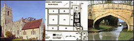
Architect's Plan of New Farm House at FURTHO (for Arnold's Charity) showing 2 sections through entire house, elevation of outbuildings, south elevation, west elevation & north elevation Architect: W.D. Gibbins of St. Giles Street, N'ton
Size Scale: 8 ft. to 1 inch
Ink & colour wash on paper.
Pencil annotations Annotated "This is the plan from which I made my tender of £1,250 dated Sep.18. 1907 John Wareing — contractor"
|
|
| 282. |
1907
|
|
Map 4502
Architect's Plan of New Farm House at Furtho (for Arnold's Charity) showing ground plan, chamber plan, basement plan, & plan of roof (rafters) Architect: W.D. Gibbins of N'ton
Size: 30 ins x 22 ins.
Scale: 8 feet to 1 inch
Ink & colour wash on paper
Pencil annotations.
|
|
| 283. |
1907
|
|
Map 4503
Architect's Plan of New Farm House at Furtho (for Arnold's Charity) consisting of Block Plan showing drains linking the House with the Horse Yard & outbuildings. Also shows churchyard, garden & pond. Architect: W.D. Gibbins of St. Giles Street, N'ton.
Size: 29 ins x 22 ins.
Scale: 33 feet to 1 inch
Ink & colour wash on paper
Pencil annotations.
|
|
| 284. |
November 1907
|
|
Map 4504
Architect's Plan of new farm house at Furtho (for Arnold's Charity) showing details of front stairs with sectional elevations & plans of stairs (ground floor & first floor) Architect: W.D. Gibbins A.M.I.C.E. of N'ton
Size: 30 ins x 22 ins.
Scale: 1 in to 1 foot
Ink, pencil & colour wash on paper.
Pencil annotations.
|
|
| 285. |
November 1907
|
|
Map 4505
Architect's Plans of New Farm House at FURTHO (for Arnold's Charity) showing details of Porch (plan & front elevation)
Scale: 1 foot to 1 inch & details of Eaves
Scale: Half full size Architect: W.D. Gibbins of N'ton
Size: 30 ins x 22 ins
Ink and wash on paper
Pencil annotations.
|
|
| 286. |
|
|
Map 4506
Plan of Old Manor House, FURTHO showing plan of ground floor, with dimensions of rooms, and names or uses of rooms including dairy, churn room, brew house, cows, pigs & fowls
Size: 26 ins x 20 ins
Scale: ⅛ in to 1 foot
Architect: not named
Pencil and colour wash on paper
Plan "No.1"
|
|
| 287. |
Undated
|
|
Map 4507
Plan of Old Manor House, FURTHO showing front elevation (with bay windows), bedroom plan with grainery adjoining, and basement plan
Size: 26 ins x 20 ins
Scale: ⅛ in to 1 foot
Ink and wash on paper Architect: not named
Plan "No. 2"
|
|
| 288. |
Undated
|
|
Map 4508
Plan of the Manor House, FURTHO showing Ground Plan of House & outbuildings with dimensions & use of rooms (harness room, gig house, churn room, dairy, milk stands). Also shows new road.
Architect: M. Holding A.R.I.B.A. of 1 Market Sq. Ntton
Scale: ⅛ inches to 1 foot
Size: 26 ins x 20 ins
Pencil & colour wash on paper
Plan "No. 1"
|
|
| 289. |
Undated
|
|
Map 4509
Plan of Manor House, FURTHO showing 1st floor plan of bedrooms, w.c. & storeroom, 2nd floor plan of bedrooms & store room, with outline of roof of adjoining outbuildings
Size: 26 ins x 20 ins
Scale: ⅛ in to 1 ft.
Architect: M. Holding, A.R.I.B.A. of 1 Market Sq. N’ton
Pencil & colour wash on paper
Plan "No.2"
|
|
| 290. |
Undated |
|
Map 4510
Plan of Manor House, FURTHO showing South elevation of main building connected outbuildings Architect: M. Holding A.R.I.B.A. of 1 Market Square, N'ton
Size: 26 ins x 20 ins
Scale: ⅛ ins to 1 ft.
Pencil & colour wash on paper
Plan "No. 3"
|
|
| 291. |
|
|
Map 4511
Plan of the Manor House, FURTHO showing Ground Plan.
Compass points shown
Size: 26 ins x 20 ins
Scale: ⅛ in to 1 foot
Brown ink with pencil on paper
Plan "No. 1"
|
|
| 292. |
|
|
Map 4512
Plan of the Manor House, FURTHO showing First Floor Plan & Attic Plan
Size: 26 ins x 20 ins
Scale: ⅛ in to 1 foot
Brown ink with pencil on paper
Plan "No. 2 "
|
|
| 293. |
|
|
Map 4513
Plan of the Manor House, FURTHO showing South elevation, & 2 sections showing position of internal staircases.
Size: 26 ins x 20 ins Scale: ⅛ in to 1 foot
Brown ink with pencil on paper
Plan "No. 3"
|
|
| 294. |
Undated
|
|
Map 4514
Plan of the Manor House, FURTHO showing North, with sketch or East & West elevations porch
Size: 26 ins x 20 ins Scale: ⅛ in to 1 foot
Brown ink & pencil on paper
Plan "No. 4"
|
|