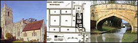
|
The Buckingham Arm in the 1950's
by
Keith Baud
Having a passing interest in canals (holidays on the Shroppie, Ashby and Caldon canals over the past few years) I was aware of the existence of the Buckingham Canal Society and their efforts to get at least part of the Buckingham Arm back into commission.
As I was born in Old Stratford in 1947, and lived in the South Northants/Milton Keynes area until I moved to Devon in 1986, I knew the Stratford Arm particularly well from boyhood rambles along its overgrown banks. Whilst too young to actually remember the canal in its working days, I can certainty remember working boats on it, or perhaps more correctly, IN it. But more of that later...
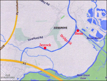
Although I can remember other bits of the Arm, and parts of the Grand Union when it carried working boats, my main story concerns the stretch of canal between what is called Bridge No 2 on the Stratford Arm (785418) and Bridge 5 on the Buckingham Arm (774401). The reason for this is that this encompasses the approximate area that a 10 year old's legs were likely to carry him from his home!
Bridge 2 was a lovely stone structure with a wooden farm gate and stile at its northern side. It certainly had water underneath it in the '50's, as did all this stretch. The parapets were in good condition, the stone wall on the south eastern side was a bit ruined where people climbed over It to gain access to the towpath and the towpath went underneath the bridge on the southern side. Certainly the towpath lay along this side of the canal for its whole length at least as far as Deanshanger.
The bridge serviced a stony track that ran from a gate on the Cosgrove road opposite what is still known as the "Quarries", and is still I think used by the Scouts for camping. This whole area both sides of the Cosgrove Road had obviously been used for quarrying as the fields were full of humps and bumps. The track to the bridge ran south along the edge of a field (with a dry stone wall on its eastern edge) to Bridge 2. This field was lower than the track, canal and Cosgrove road. In fact the Cosgrove road ran along the top of a small 15/20foot cliff face which was obviously the face of the quarry (limestone). The canal ran along a low embankment that gradually increased in height as it crossed Dogsmouth Brook. As a child this embankment seemed HUGE, I am sure it looks very small today!
The field also held a rubbish dump close to the Cosgrove road which we were always warned to stay clear of. It contained a lot of ashes, still hot underneath, and one of the Slaymaker brothers was badly burnt when he fell through the crust that covered it.
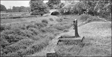
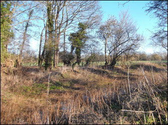
The canal executed a long curve on this embankment and was in water. I am glad you have identified the paddle gear and culvert at 783417. My memory recalls that this was a brick lined semi-circular culvert that ran down the southern slope of the hill through an area of rough land and into the brook. One of our favourite pastimes was damming this culvert with puddled clay from the brook which implies that there must have been water coming down it at times - meaning water in the canal.
The culvert which took Dog's Mouth Brook under the embankment was obviously a source of great interest to the local lads, it is reputed that some of the more daring waded through it to the far end. It is called Dog's Mouth Brook by the way because of a spring that used to issue from a Dog's Mouth in the bank near the road bridge over the brook on the old Northampton Road at its junction with the Cosgrove road.
The section of the canal between the Dog's Mouth culvert and what is now the ASD was never easily accessible, as the towpath was heavily overgrown. We did get along it in 1963 however when the canal froze over for months.
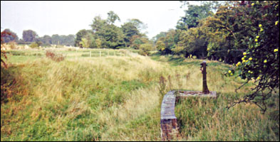
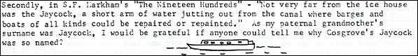
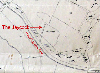
There was certainly a short arm at 782414 and I seem to recall a building made out of corrugated steel sheet and painted black near it, although whether it was a wharf or not I would not like to guess. This arm lay in the far (eastern) corner of a rectangular field bounded on two sides by the canal and was well overgrown in the 50's. In later years David Adams of Bridge Farm (opposite Riverside Garage) established ACE Plant Hire in this field.
At the south-east corner of this field the canal made a 90 degree turn west, with a short arm going straight into what we called “The Wharf". Although we never went into "The wharf" (it was private property), a little niggle at the back of my mind says there must have been a way of crossing this arm to gain access to the towpath which continued on the southern side of the main cut. I note that you have found evidence of a swing bridge at 782413 and this must have been it. By the late 60's the Wharf Arm had dried up and we used to walk across it through the reeds.
This junction seemed quite big as a child, it was certainly quite an expanse of water and a popular fishing spot. There was also an old punt here, covered in black tar that we used to use to make the odd foray onto the waters of the canal. As I said, I think I can only ever remember going into Hayes Wharf once and this was from Wharf Lane. I can remember a great barn of a place like a Dutch barn, with old walls overgrown with ivy. From the junction with the Wharf arm to Bridge 1BA/4 at 781413, the canal ran along the north side of another rectangular field that served as the village recreation ground (known as the Rec.). I think there are houses there now. The boundary between the "Rec" and the canal was a high unkempt hedge with plenty of gaps to access the towpath. The eastern boundary of the "Rec" was the old stone wall of Hayes Wharf. The western boundary was Cosgrove Road - the old A422 to Northampton. As the major junction of the A5 and A422 from Northampton to Oxford, Old Stratford was very busy place before the opening of the M1.
The enigmatic Bridge 1.4/4....
I can remember this bridge when it was a conventional narrow "hump backed" bridge so I would guess that is in the ‘50’s. However, as I said, the A422 was a busy road and after an Army tank transporter (Diamond T or Mighty Antar - I cannot remember which) grounded out on it one day the local council decided to lower the bridge.
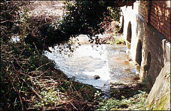
They constructed a new flatter concrete bridge that I guess is still there, and this had a towpath underneath on the south side. You could walk under it OK with just your head bent (about 5' 6" headroom I would guess) so from water level there should be enough room for a boat. There was always plenty of water in this stretch of canal and definitely NO dam! The towpath was accessed by an inclined path which led from the south side of road near the entrance to the "Rec" and along between the wall and the road.
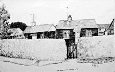
After this bridge the canal turned south west along the back of 6 wooden bungalows between it and the Cosgrove road and towards the bridge under the "old" A5. On the right was a field, but closer to the A5 bridge there was a Wharf. This was known as Slaymaker's yard after the farmers who owned it. There was a tall brick building on the right, then an open yard area edging the water where boats presumably unloaded, then a long stone barn whose south eastern wall fell straight into the water. This whole complex was accessed through some fine wooden gates just to the north of the row of small brick built terrace cottages fronting the A5 to the north of the canal.
To the south of the towpath at this point, on the corner of the A5 and Cosgrove road, was Chapman's Yard where the Chapman brothers had a coach-building business building wooden cattle lorry bodies and carts. There was also a forge here where they used to make their own ironmongery and fittings and sweat steel bands onto wooden cartwheels. Two of the brothers lived in two of the aforementioned wooden bungalows that I think they built. The towpath at this point climbed up a ramp to join the A5 on top of the bridge.
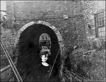
I was rather intrigued to see this bridge no 2/5 (779412) referred to as the Old Stratford Tunnel. This is the first time I have heard this expression and whilst I do not remember a towpath underneath it, I think I am right in saying that I do not think it was always this long...
|
|
|
In 1970 the stone arch bridges over the Old Stratford Arm had been bulldozed.
|
Dredging back in my memory I seem to recall that the A5 and its verges were widened at some point in the '50s. I might be wrong about this but whilst the parapet on the north-eastern side of the bridge is original, I am sure that the one on the south west side is of newer construction. I also seem to remember that the bridge portal on this side is of newer flat construction as opposed to the original arch on the north-east side which indicates that the bridge changes shape halfway through. I could be totally wrong about this, I haven't been down to the canal side by this bridge for about 25 years, but it might be worth investigating.
The towpath rejoined down a ramp on the south-eastern side behind the village shop and the canal continued in a shallow cutting past the rear of the Memorial Hall, a row of houses, an allotment and then two brick built bungalows all sandwiched on the narrow stip of land between the canal and the Deanshanger Road. In the first bungalow lived the Knight family, "Mowey", Agnes and their only son Peter. "Mowey" was the local "bookie" and Peter, being born about a year after me, is my oldest friend. He was always constructing oddball things, like rafts constructed from shed doors and oil drums, and launching them into the canal which bordered their back garden. They invariably sank!
The next bungalow was lived in by the Millward family. I cannot remember their names. They had an interest in the coal yard next door
The final building on the ever narrowing strip of land between the canal and the Deanshanger Road was Millward Bros. Coal Yard. This comprised of an old timber and corrugated iron shed and a small coal yard. The canal ran right along the back and I can only assume that coal was unloaded here for transhipment in the past. This was at 77854105. Nick Millward, the son of one of the owners, inherited the land from his father and subsequently had two or three houses built on it in the mid 80's. One may be on the line of the canal. I have a photo taken in about 1953 showing the whole of the Old Stratford May Queen entourage (including myself and my sister Celia) sitting on Millward's coal Forty outside the yard. Unfortunately it does not show anything of the canal.
Now we come to the exciting bit....
After Millwards Coal yard the canal got ever close to the road until it was separated by just the towpath and a thick, unkempt hedge. On the north west side of the canal at this point, after the council houses of Mount Hill Avenue, was a small rectangular field, which the village team used as a cricket field for a couple of seasons after they were thrown out of the Black Horse field at the top of the village. It was never much good as a cricket field as it was really too small, wet and bumpy.
The canal edge had a number of willows along it at this point, but in it were two abandoned narrowboats - a tug and butty. I can still clearly remember them and although our parents used to warn us off playing on them for fear of us getting trapped and drowning - we still did. I am pretty sure they were of wooden construction, but they were sunk and listing, the holds full of water, timbers green with lichen, their small cabins dank and mouldering. I can still remember the great rusting hulk of an engine in one. They faced towards Buckingham and I reckon they must have been there a few years, but after the last boat to Leckhampstead in 1932 or it could not have passed!
They eventually extended Mounthill Avenue and built what is now Willow Grove on this field in the early ‘70's?, filling in the line of the canal and cutting a new road through it from Deanshanger Road. The line of the canal can still be discerned between Deanshanger Road and Willow Grove as a slightly raised hump and beneath this the remains of two old narrowboats still might lie. What a project for the "Time Team!". As far as I can remember they will be buried between what was Millwards Yard and the entrance to Willow Grove (77854100).
Moving south you have correctly identified the location of Bridge 3. This bridge led into the aforementioned rectangular field and into a marshy area at the foot of another field. The track that lead over this bridge was opposite Holtons Garage and I think the Holton family built a bungalow in the "marshy" bit and used the bridge as access to it. It was certainly originally a timber bridge with a planked deck and wooden handrails but I think it was later replaced. I think the grid reference for this bridge should be 778408.
After this bridge the canal followed the line of the Deanshanger Road on its western side, again slightly below the level of the road. It was separated from the road by a high hedge but had plenty of water in it. Where the Deanshanger road bent right as it left the village a length of iron railings separated the canal from the road to allow vision on what was a dangerous corner, this also allowed a view of the canal as it swept around the bottom of a field.
This field was accessed by another timber bridge - your Bridge 4 - which has probably now been buried under the junction of the new Old Stratford bypass. There was water in the canal at this point although the section after the bridge towards Deanshanger was heavily overgrown, at this point the canal began diverging from the road again, its line defined by a row of trees and a hedge on the towpath side.
Bridge 5 (Puxley Road) at 774401 was about the limit of my youthful wanderings. Again I can remember this as a timber bridge, I think it was replaced with the existing structure in the early '60's. The pipe went in about the same time I think.
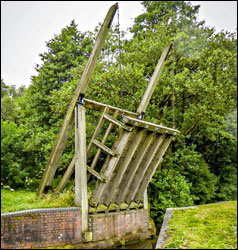
The odd thing about these timber bridges is that I can remember no evidence of how they worked. I do not remember any uprights or balance beams that would indicate they were lift bridges, but the ends of the bridges were square, not radiused as you would expect with a swing bridge. On balance I think they were probably lift bridges but with the lifting gear long removed.
I can also remember odd stretches of the canal as it went through Deanshanger, our School Bus to Towcester used to go that way. Bridge 8 and 9 in Deanshanger were both narrow "hump backed" bridges but bridge 7 was a timber decked one as you so rightly deduce. After Bridge 9 the canal curved east behind what is now a small housing estate, a pub (Kings Head?) and school to rejoin the line of the A422. I think there were a couple of bridges on this section serving fields, bit for their exact location you would be better speaking to someone from Deanshanger.
Obviously, the new Deanshanger bypass has destroyed much of the next section of canal but when travelling along this road on a bus in the direction of Buckingham you used to be able to see the line of the canal quite clearly across the fields to the north.
Finally, I can remember the lattice girder bridge on the Thornton road (750365) .
I never did quite understand what the canal did in the vicinity of Cattleford Bridge (742364) but wonder of the road eventually adopted the line of the canal. Back in the 70’s I needed some old bricks for an extension I was building on a cottage at Wicken and knew of a small derelict barn in the field by the side of the road at this point. I bought the “barn” from the owners and transported the bricks to Wicken on a tractor and trailer. I have absolutely no idea whether the barn originally fulfilled a canal function, or whether it was a farmer’s barn. Whatever, as this part of the world is predominately stone I would guess those old bricks originally came in by canal!
The owners of the barn were the Merchant Venturers, who used to own a lot of land in the Wicken/Lechampstead area. Their land agents were based in Oxford I think. It might be worth contacting them to see what ownership records they have for those stretches of canal.
Living where I did I also have memories of the Grand Union when it was still carrying working traffic. We used to go fishing on the canal between Yardley Wharf and Grafton Regis. You could tell when a working pair were coming long before they got to you as the water level would rise with the amount they were pushing along and fall then as they passed, the water virtually up to their cloths.
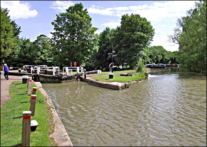
A popular Sunday walk would be to Cosgrove to have a drink at the Barley Mow, or in the other pub long closed, that was on the other side of the canal through the dark wet tunnel under it. We also used to walk to the locks to watch boats working through, and then right along the embankment and over the Iron Trunk to the Galleon.
I remember when the Sand and Gravel pits were working at Cosgrove (Cosgrove Caravan Park now). A little diesel engine used to pull trains of tipping trucks up from the grading plant at the quarry to the wharf edge before the locks, you can still see the rails today I believe. As kids we used to hitch a ride on the short bumpy journey.
I can remember the short stretch of canal known as the “Black Boards” after the high wooden fence that skirted Wolverton Carriage and Wagon Works between the station and the rail skew bridge over the canal. As a train-spotter we used to go regularly to Wolverton station where you had the double joy of steam on the railway and the working boats on the canal. A flight og wooden steps led down from the road near the station to the canal alongside the carriage works, the towpath affording an excellent view of the main line.
Like many of my contemporaries, when Milton Keynes started being built, I took up tools in the building trade and worked for many years as a carpenter on various sites and projects in the area. Once in the early 70’s, when between contract, I worked for a few months at Faulkner’s Yard in the Old Brewery at Cosgrove fitting out narrowboats. I recall they were steel hulls with a plywood superstructure that we built in a barn at 90degrees to the cut so they were launched end-on, not sideways.
I hope these reminiscences are of some use to your efforts in restoring the Buckingham Arm and wish you all every success with the project. I am a little too far away to offer any practical assistance but I am sure that with a bit of prompting the old memory banks might come up with a few more nuggets of useless information!
|