The parish covering some 700 hectares, is roughly oval and lies on a broad spur bounded by the R. Tove on the E., the Great Ousc on the S.E., and the Dogsmouth Brook on the S. W. From the wide alluvial valleys of the two rivers at about 64 m. above OD the land rises across Oolitic limestones and clays; the higher ground, above 85 m., in the central, N. and W. areas is covered by Boulder Clay.
The most important archaeological remains in the parish are the Roman villa, bath house and temple (2). The modern parish is the result of both ancient and recent adjustments. Baker (Hist, of Northants., II (1836-41), 128) wrote that 'this parish, prior to the inclosures, was inconveniently and inexplicably intermingled with Potterspury', and maps show that it included at least two detached areas now in Potterspury. In 1954 the creation of Old Stratford parish involved the transfer of the S.W. part of Cosgrove.
PREHISTORIC AND ROMAN
A few late Neolithic or Bronze Age flints and some pottery, perhaps sherds of a beaker, were discovered during the excavation of the Roman buildings (2) (BNFAS, 4 (1970), 8) and a bronze spearhead was found in about 1967 close to the R. Ouse in the E. of the parish (SP 80104206; Bucks. County Museum).
a(1) RING DITCHES (?) (centred SP 795419), on river gravel, between 64 m. and 71 m. above OD. Air photographs (not seen by RCHM) are said to show the crop-marks of two ring ditches (SP 79564190 and 79584188), with a third 250 m. to the W. (OS Record Cards). From the description it is possible that these are the ploughed out remains of a wartime anti-aircraft emplacement (see also Old Stratford, p. 108).
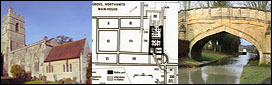
a(2) ROMAN VILLA, BATH HOUSE AND TEMPLE (SP 795421), S. of the village, on limestone, at 70 m. above OD. The discovery of an urn containing 60 silver denarii (Gent's. Mag., 1 (1801), 76) and of many other Roman coins including silver medallions of Constantine I, Valentinian II and Magnus Maximus, as well as coins of Diocletian, Constans, Magnentius, Julian, Valens and Gratian (Baker, Hist, of Northants., 2 (1836-41), 136; VCH Northants., I (1902), 216; OS Record Cards), all probably found during the construction of the canal, suggested the presence of a Roman settlement in the area. An undated burial had also been discovered in the vicinity. Excavations in the 1950s revealed a well-preserved bath house and in 1969 the main buildings of a villa were investigated. These covered more than 1 hectare and were arranged around a large courtyard. The main building, a double-corridor villa, was built in about AD 100 and survived for about 200 years. The bath buildings constructed in about 150 went out of use before 300. Another less sophisticated double-winged building was occupied about 100 -150. A small temple built in about 300 may have replaced earlier ones. Other walls and buildings were also found. (BNFAS, I (1966), 7; 4 (1970), 7-8; JRS, 48 (1958), 140; 49 (1959), 115; Wolverton and District Arch. Soc. Newsletter, 4 (1959), 7; 7 (1962), 2-4; Britannia, 1 (1970), 288; CBA Summaries of Excavations (1969), 1 1; MOPBW Arch. Excavations 1969 (1970), 21; OS Record Cards)
MEDIEVAL AND LATER
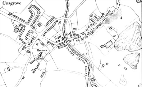
a(3) MOAT (?) (SP 796432), lies on the N.E. side of The Priory, close to the R. Tove, on river gravel at 64 m. above OD. An L-shaped ditch with a maximum depth of 1.3 m. is correctly shown on OS 1:2500 plan SP 7943. There is no trace of other sides and it is uncertain whether the feature is a genuine medieval moat or a later landscape feature. The latter is more likely.
a(4) SETTLEMENT REMAINS (SP 796427; Fig. 15), formerly part of Cosgrove, lie at the extreme N.E. end of the village, on river gravel, at 65 m. above OD. Faint traces of a hollow-way, continuing the line of Main Street and The Green, are visible running N.E. towards Castlethorpe, Buckinghamshire. To the S.E. of The Green and cut into by later gravel-pits are very indeterminate earthworks which may be the sites of former houses. Though these remains are slight, they emphasize the relatively simple layout of the village before it was disrupted by the construction of the Grand Junction Canal in 1800. Until then the village probably consisted of a single street extending from the church in the S.W. to The Green. The Main Street was blocked by the canal, except for pedestrian use, and traffic was diverted in a broad loop to the N. on which all subsequent development has been based. The Rectory garden and the new graveyard have obliterated any trace of the original street between the canal and the church but a modern footpath follows the approximate line. (RAF VAP CPE/UK/1926, 4248-9)
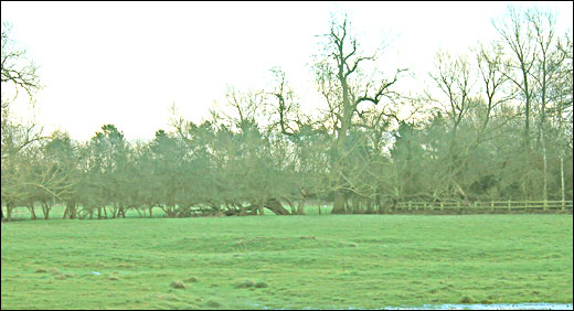
(5) CULTIVATION REMAINS. The common fields of the parish were enclosed by an Act of Parliament of 1767 (NRO, Enclosure Map). No details are known of the arrangement or the names of the fields before that date. Ridge-and-furrow of these fields exists on the ground or can be traced from air photographs in a few places, mainly alongside the R. Tove and the Great Ouse, arranged in end-on and interlocked furlongs, many of reversed-S form. Some exceptionally well-preserved ridge-and-furrow remains immediately N. of the village (SP 793427), where it is cut by both the canal and Bridge Road, and to the S.W. of The Priory (SP 795429). Another common field, a detached part of the parish the exact location of which is unknown, was enclosed with the fields of Potterspury in 1775. (Baker, Hist, of Northants., II (1836-41), 128). (RAF VAP CPE/UK/1926, 2245-9, 4246-9; F21 58/RAF/5517, 0029-32; F22 58/RAF/5517, 0030-2; air photographs in NMU)
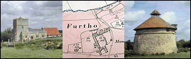
For the cultivation remains of the deserted village of Furtho, some of which lie in this parish, see Potterspury (17).
UNDATED
a(6) BURIALS (SP 781427), W. of Rectory Farm, on glacial gravel at 85 m. above OD). Several skeletons were found in a gravel-pit in about 1893-4 (OS Record Cards).